
Mercator has a particular talent for the far north. Greenland swells. Canada smears. The Arctic Ocean collapses into a decorative blue trim along the top of the poster, as if the planet came with margin notes for the printer.
The ocean is not a margin note.
Arctic Ocean in Map Real Size: 11,380,001 km².
That is about 3.6× India (~3.16 million km² in the same app). Larger than China. In the same conversation as the Philippine Sea, except this one sits on top of the planet and gets cropped out of the classroom poster.
Smallest ocean, still not a pond
Yes: of the five named oceans, this one is the smallest. The phrase has done more damage than the projection. “Smallest” sounds like something you could swim across before lunch. A few facts the trim never mentioned:
- Average depth is only about a kilometre — shallow by Pacific standards — but the deep basins still plunge past 4,000 m, split by the Lomonosov Ridge, an underwater mountain chain running toward the pole that Russian scientists mapped in 1948.
- It is the least salty of the major oceans: heavy river input, low evaporation, limited mixing with saltier neighbours.
- Roughly half its area sits on continental shelves. The deep part is two main basins. Ice in the Beaufort Gyre can circle for years; the Transpolar Drift walks floes toward the Fram Strait between Greenland and Svalbard — the deep gate to the Atlantic. The Pacific connection is the narrow Bering Strait.
- When Nansen froze the Fram into the pack in the 1890s and drifted with it, he was treating the Arctic as a system with a current, not a white scribble.
Sea ice still covers most of the basin in winter and shrinks hard in summer; that seasonal lid reflects sunlight and helps set weather far south of the pole. Depth records belong to Pacific trenches. Area is the argument the wall map keeps losing.
Look down from the pole
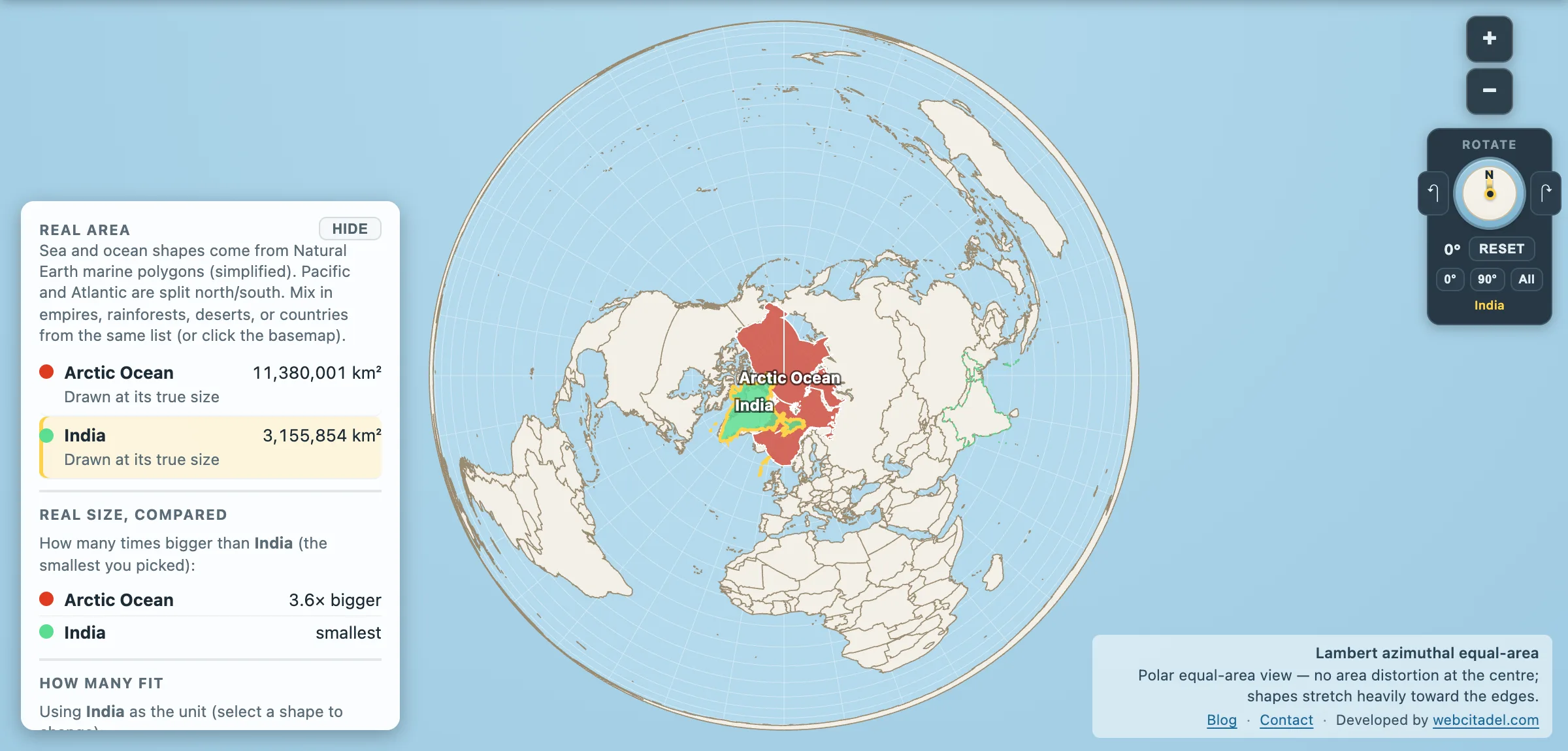
Cylindrical maps stretch high latitudes and often crop before the pole. A Lambert azimuthal equal-area view centred on the Arctic does the opposite job: honest area at the centre, ocean as basin, land as a ring.
Open the Arctic with India overlaid. Drag the subcontinent. A country of 1.4 billion people fits several times over inside the “small” ocean. Flip back to Mercator afterward for nostalgia. Just don’t trust the trim.
Wider distortion story: why Mercator lies about almost every country.
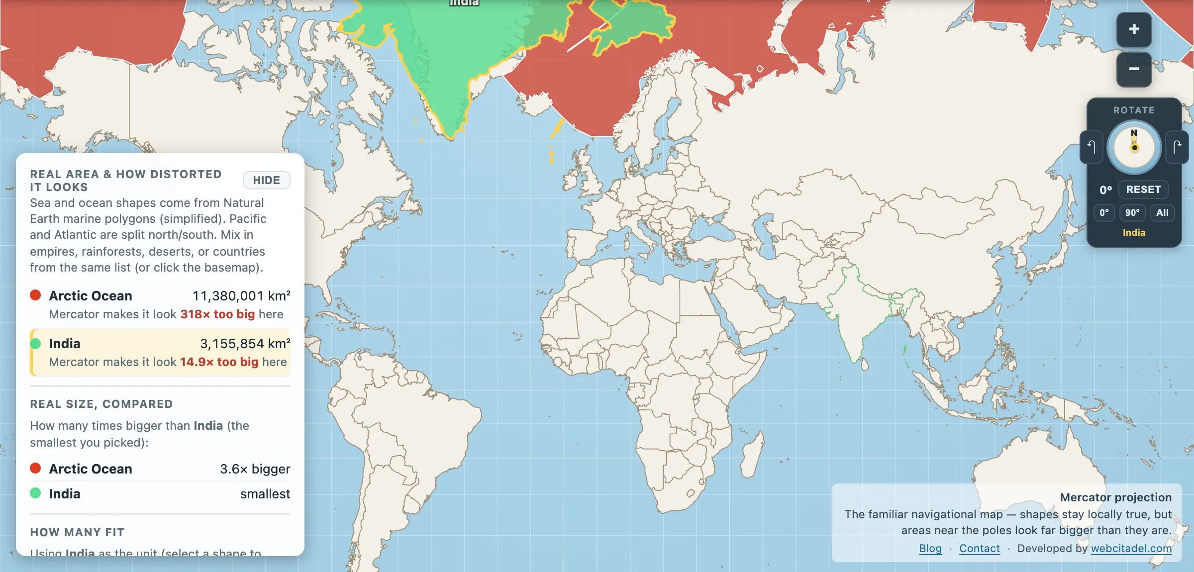
The same shapes on Mercator — the projection almost every map you see uses. Watch what it does to anything far from the equator.
Sources & methodology
- Arctic Ocean polygon/area: Natural Earth marine regions, expanded in Map Real Size by unioning the NE central “Arctic Ocean” basin with adjacent seas that atlases usually fold into the Arctic total: Barents, Kara, Laptev, Chukchi, Beaufort, Greenland, Norwegian and White seas. The raw NE “Arctic Ocean” polygon alone is only ~5.2 million km² (central basin) — about Arabian Sea sized — which understates the common ~14 million km² encyclopaedia figure. Our union lands near 11.4 million km²; remaining gap is mostly seas/edges NE does not draw separately (e.g. East Siberian Sea).
- Those adjacent seas remain available as their own pickable shapes for local comparisons.
- India: country polygon in the app (~3,155,854 km²).
- Azimuthal equal-area is equal-area by design; shapes stretch toward the rim.