
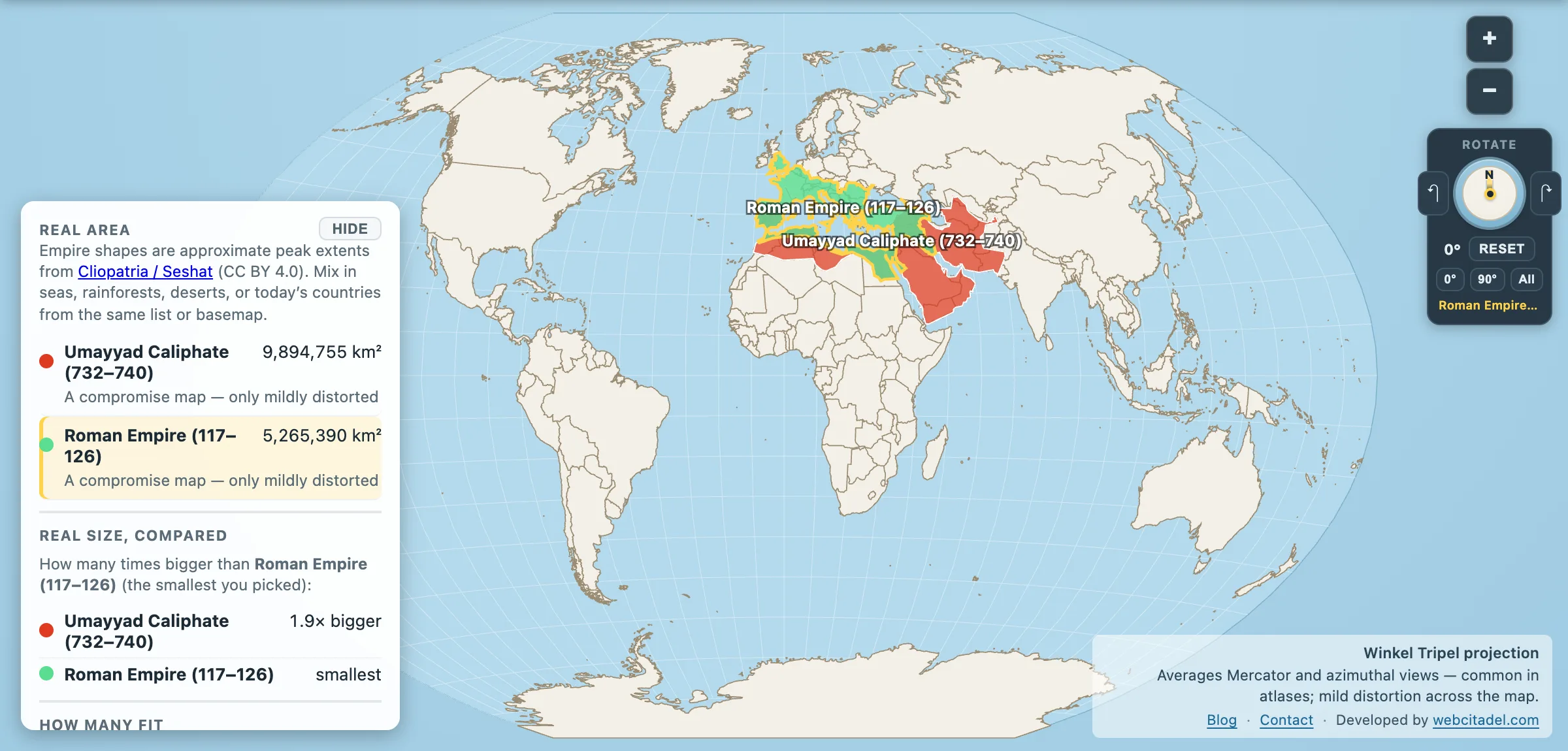
Rome owns the ruins, the Latin homework and the default meaning of the word empire. Ask which state ran the largest late-antique map and the answer still arrives in a toga.
Try the eighth century.
Using the Cliopatria / Seshat peak extents in Map Real Size:
- Roman Empire (117–126): 5,265,390 km²
- Umayyad Caliphate (732–740): 9,894,755 km²
About 1.9× Rome in this dataset. Larger than the modern United States in the same country layer. In its expansive decades the caliphate ran as a continuous band from the Atlantic face of Iberia across North Africa and the Near East toward the edges of Central and South Asia — Mediterranean as western lake, not the centre of the story.
A machine with a capital in Damascus
The Umayyads were the first hereditary caliphate, governing from Damascus after the Rashidun period. Their century was short by Roman standards and loud by everyone else’s:
- Under Abd al-Malik and his successors, Arabic became the language of the state registers — replacing Greek and Persian paperwork across a tax machine that had been Frankenstein’d from older empires. Coinage shifted toward epigraphic Islamic designs. Administration got an ideology, not just a loot schedule.
- In 691–692 the Dome of the Rock rose in Jerusalem — still often called the oldest surviving major Islamic monument. Al-Walid I’s Great Mosque of Damascus followed as architecture-as-billboard: permanence, in stone, on the old cathedral site.
- In 711, forces crossed into Iberia; within years much of the peninsula was Al-Andalus. A later Umayyad exile line in Cordoba would turn that western foothold into one of medieval Europe’s great cities — estimates for tenth-century Cordoba often put it over 100,000 people, rivalling Constantinople for the title of largest city in Europe. Rice, citrus and new irrigation habits moved with the same currents.
- In 732, Frankish forces stopped a raid near Tours/Poitiers. European memory later inflated the clash into the salvation of Christendom. The caliphate’s centre of gravity stayed east either way; the raid was not the fall of Damascus.
Was every border neat? No. Other encyclopedias and record books quote different peaks because they pick different years or count vassals and desert claims differently. Map Real Size’s number is simpler: the area of that reconstructed polygon.
Within the same catalog the Umayyads still trail Spain’s global peak and the British and Mongol ceilings. “Nearly two Romes” is already enough to retire the toga as the only yardstick. For another Mediterranean pairing: Ottoman vs Rome.
Overlay them
Open Umayyad vs Rome on Winkel Tripel, the compromise projection National Geographic made familiar. Drop Rome onto the caliphate. The Mediterranean superpower becomes a large province inside a wider east–west machine — roads and Latin on one side of history, Arabic registers and a dome on the rock on the other.
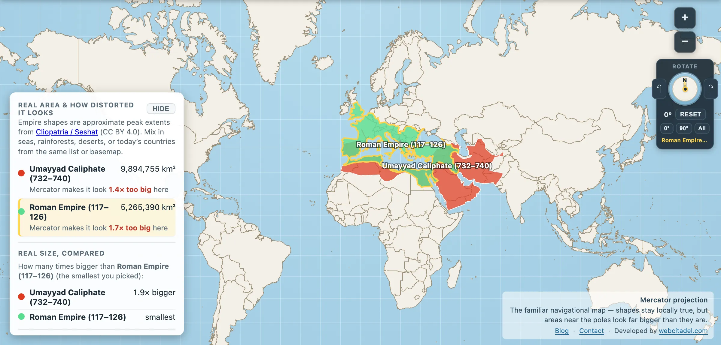
The same shapes on Mercator — the projection almost every map you see uses. Watch what it does to anything far from the equator.
Sources & methodology
- Empire polygons/areas: Cliopatria / Seshat (CC BY 4.0), simplified for Map Real Size. Year labels are the dataset windows in the picker.
- Institutions & monuments: standard narrative on Abd al-Malik’s reforms, Dome of the Rock (691–92), Damascus Great Mosque; Cordoba population estimates vary widely by historian (100,000+ is a common lower bound for the later caliphal city — after our 732–740 snapshot).
- Disagreement with Guinness/textbooks: expected. Peak year and inclusion rules change the total. Cite method with magnitude — here, polygon area of the Cliopatria reconstruction.