
In 326 BCE, on the banks of the river the Greeks called the Hyphasis — today’s Beas, in northwest India — Alexander’s army stopped. They had beaten Porus at the Hydaspes. They had named cities after themselves across three continents. They would not take another step east. Alexander shut himself in his tent for three days, then gave in, and ordered twelve colossal altars raised to mark the edge of the expedition. The altars are lost. The sentence remains: this is as far as the known world goes.
A rainforest on a continent none of them had language for was already larger than everything he held.
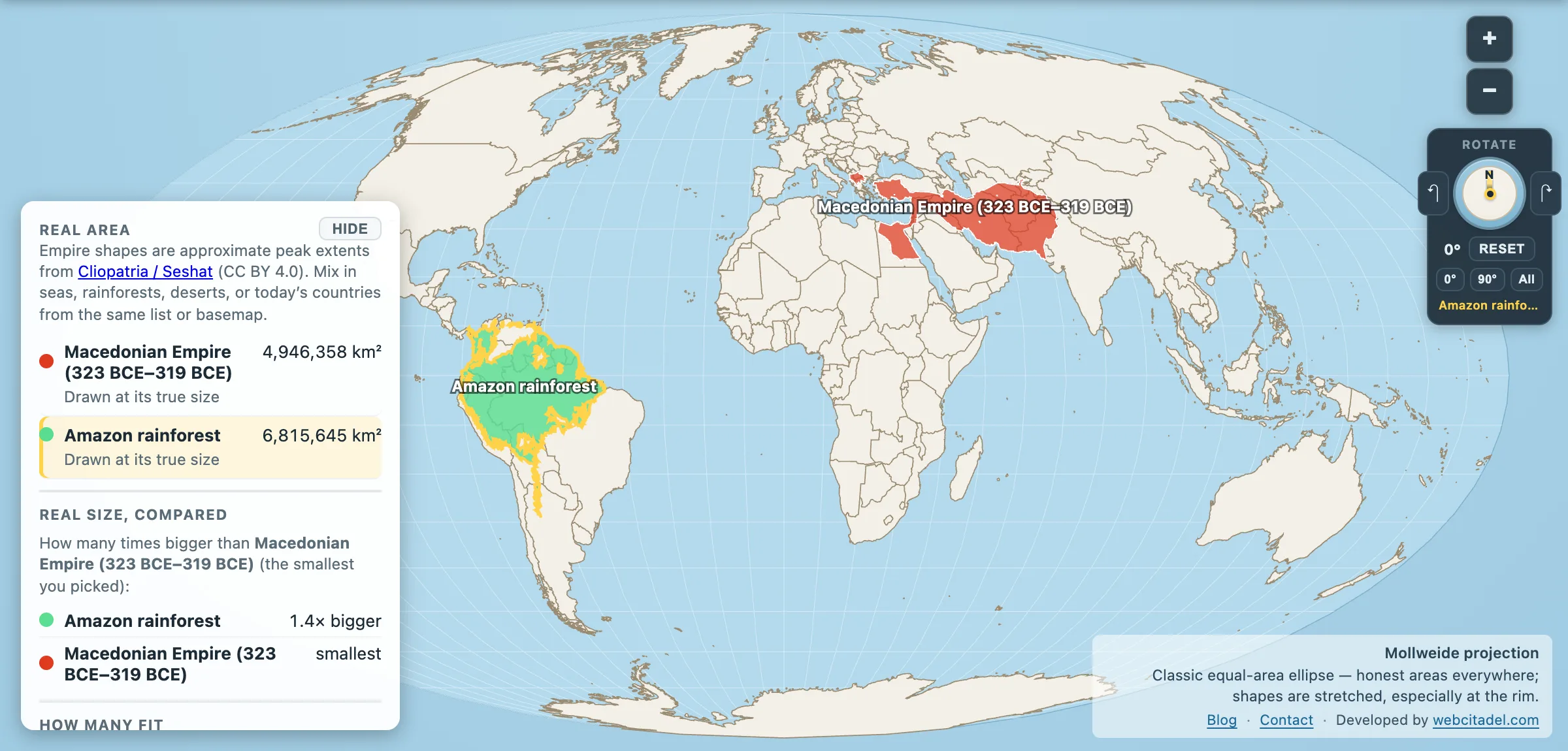
Using Map Real Size’s empire and rainforest layers:
- Macedonian Empire (323–319 BCE snapshot): 4,946,358 km²
- Amazon rainforest (moist-forest ecoregion union): 6,815,645 km²
The forest leads by roughly 1.9 million km² — about three Frances of canopy — without a phalanx, a satrap or a founding myth carved in stone.
A belt of conquest vs a basin of water
Alexander’s realm, even at its widest, was a political belt: Macedonia to Egypt to Persepolis toward the Indus, stitched by marches in a little over a decade. He founded (or refounded) a string of Alexandrias as administrative nails in the carpet. Astonishing for one human life. Still smaller, in the same historical dataset, than Achaemenid Persia before him. The “world” he ran out of was a neighbourhood with excellent historians.
The Amazon is not a state. In our data it is a union of tropical moist-forest ecoregions — and the river at its heart still refuses ordinary infrastructure. There is no bridge across the Amazon’s main channel for most of its length; ferries do the work that concrete does elsewhere, partly because floodplains move and roads are scarce. Discharge is in a class of its own — on the order of 200,000+ cubic metres per second at the mouth, more freshwater than any other river on Earth. Tree counts for the basin are often put near 390 billion. Empires fragment. Left alone, canopy keeps assembling biomass while kingdoms swap coins.
Park the Amazon next to the United States and the forest still looks like a country in leaf. Park Alexander’s outline on it and the known world looks like a province that got good press.
Mollweide, because area is the argument
Open Alexander vs the Amazon on Mollweide, a classic equal-area ellipse. Drag the Macedonian shape onto South America. Drag the Amazon onto the Near East. He measured glory in marches and altars. The map measures square kilometres. On that scoreboard the canopy does not need a coronation — or twelve stone markers at the water’s edge.
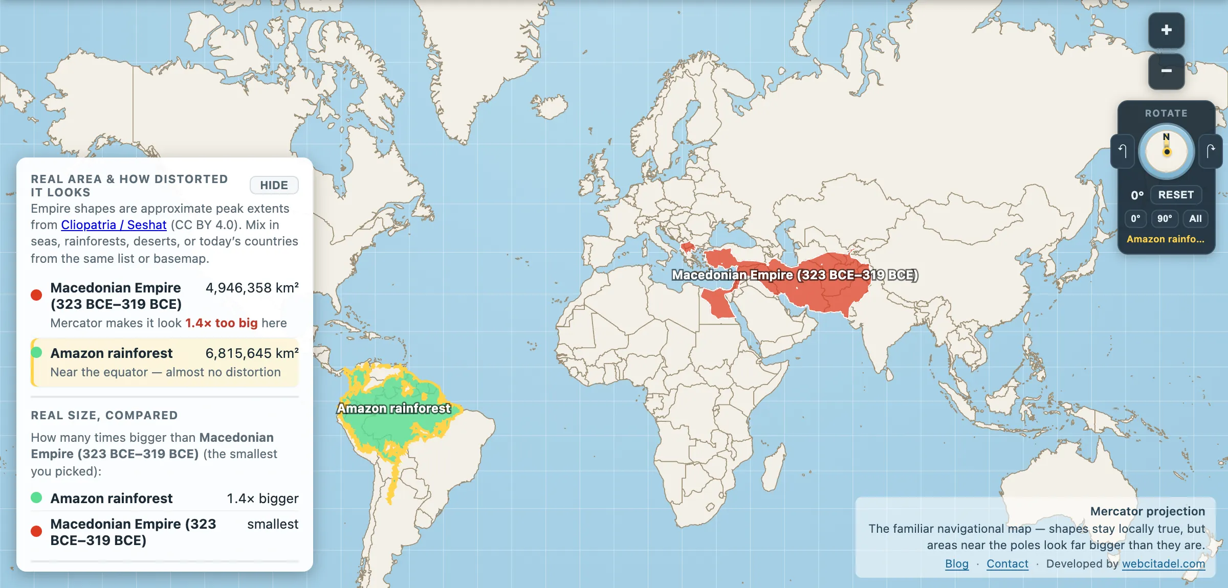
The same shapes on Mercator — the projection almost every map you see uses. Watch what it does to anything far from the equator.
Sources & methodology
- Macedonian Empire: approximate peak extent from Cliopatria / Seshat (CC BY 4.0), year window 323–319 BCE. Ancient borders are reconstructions; other references may quote different peaks. Hyphasis mutiny and altar tradition: standard classical narrative (Arrian and later summaries); altar locations remain archaeologically uncertain.
- Amazon region: RESOLVE Ecoregions 2017 moist-forest union (CC BY 4.0) — biogeography, not a live deforestation layer. River discharge and bridge notes are hydrology/infrastructure facts about the main stem, separate from the ecoregion polygon area.
- App areas are simplified polygon calculations — consistent for Map Real Size comparisons, not a substitute for a historical monograph or FAO inventory.