
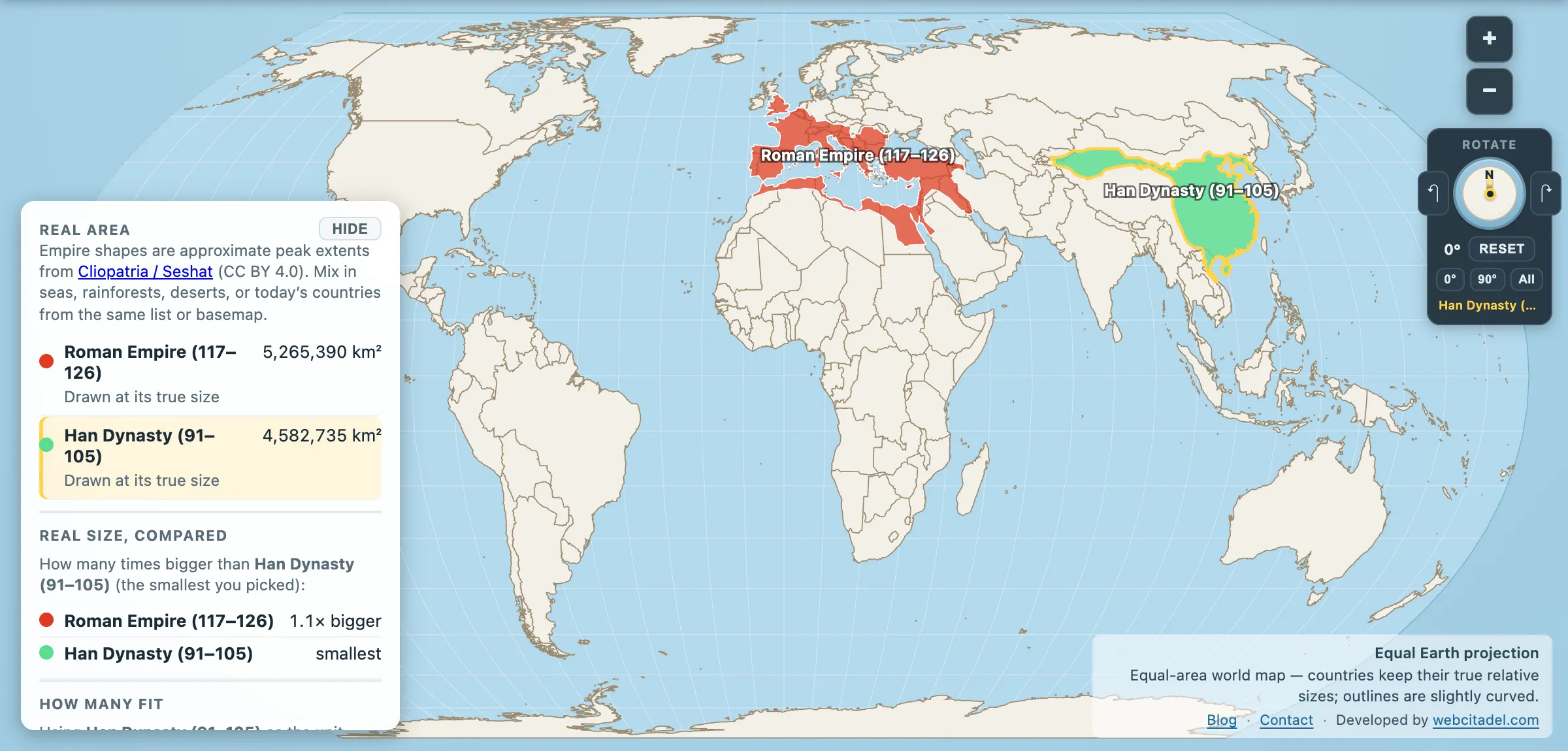
Around the year 100, two states each governed something close to a quarter of the human race. They sat at opposite ends of the same landmass, traded goods along the same road, and neither one could say with confidence that the other existed.
- Roman Empire at its peak under Trajan, 117 AD: 5,265,390 km²
- Han Dynasty at its peak, around 100 AD: 4,582,735 km²
Rome takes it by about 683,000 km² — a Myanmar of margin, on shapes over five million km². For all practical purposes these were the same size. Populations, too: both are usually estimated in the range of 50 to 60 million.
The ambassador who turned back
In 97 AD the Han general Ban Chao sent an envoy named Gan Ying west, with instructions to reach Daqin — the Chinese name for Rome. Gan Ying got as far as the Persian Gulf. There, according to the Book of the Later Han, Parthian sailors told him the crossing ahead could take two years, that men had died of longing for home on it, and that he should think carefully.
He thought carefully. He went home.
It is one of history’s great near-misses, and it wasn’t an accident. Parthia sat between them and had every reason to keep it that way — as long as Roman silver and Chinese silk had to pass through Parthian hands, Parthia set the price. The middleman’s oldest business model, defended by geography.
Contact happened eventually, and thinly. In 166 AD a party arrived at the Han court claiming to represent Andun — recognisably Marcus Aurelius Antoninus — though historians suspect merchants with a good line in credentials rather than an imperial embassy. Roman writers knew of the Seres, the silk people, and had roughly the geographic precision you’d expect from a description passed through six languages and a desert.
Two answers to the same problem
Both empires were solving the same puzzle: how do you administer more land than a messenger can cross in a season?
Rome’s answer was roads and citizenship. A network estimated at around 400,000 km, of which more than 80,000 km was stone-paved; a navy that made the Mediterranean an internal lake; and a slowly widening definition of who counted as Roman, until Caracalla handed citizenship to nearly every free inhabitant in 212.
Han China’s answer was bureaucracy and paper. A salaried civil service, standardised weights and script inherited from the Qin, commanderies reporting to the centre, and — crucially — paper, invented under the Han and formalised by Cai Lun around 105 AD. Rome ran on stone and law. Han ran on documents.
They failed at similar times, too, and for rhyming reasons: overextension, plague, currency trouble, and generals who worked out that the army was the real constitution. The Han fell in 220. Rome’s western half took another two and a half centuries, and its eastern half kept going for a thousand more.
Two ends of one road
Open Rome vs Han on an equal-area map, where a square kilometre in Gansu is drawn the same as a square kilometre in Gaul. Drag one over the other. Two shapes of near-identical size, 7,000 km apart, at the same moment in history.
Rome gets the films, the marble and the Latin lessons because Western history is written from inside it. Measured on the map, it had a twin.
Neither, as ever, troubles the all-time top of the table. And Rome wasn’t even the biggest thing in its own neighbourhood — Persia beat it six centuries earlier.
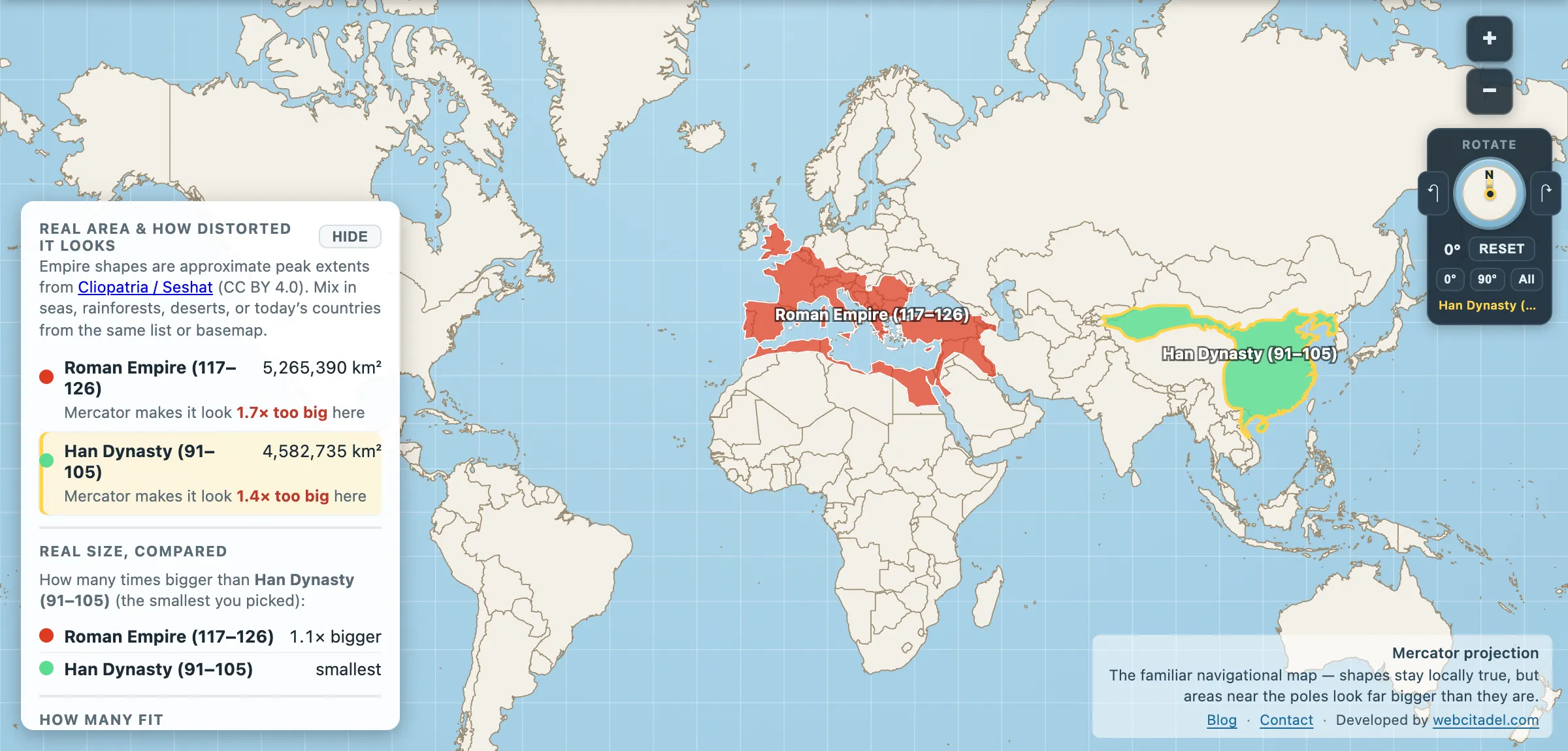
The same shapes on Mercator — the projection almost every map you see uses. Watch what it does to anything far from the equator.
Sources & methodology
- Empire extents: Cliopatria (Seshat Global History Databank), CC BY 4.0, as used in Map Real Size. Map Real Size’s own quiz uses a second, more conventional set of peak-extent figures, which puts Rome at about 5.0 million km² rather than 5.27. Both sources leave Rome and Han within a few per cent of each other, which is the only claim this post rests on. Peak extents are reconstructions from historical sources, not surveys, and reasonable scholars disagree at the edges.
- Ancient population figures are estimates with wide error bars; the “quarter of humanity each” framing is the conventional reading, not a census.
- Gan Ying’s journey is recorded in the Hou Hanshu (Book of the Later Han).